Monday 30 April 2012

UK Water Demand & Supply Case Study


Somebody asked for this, but it's not the case study I'm doing so this is just me copying what's in my book, it's all I've got since I know nothing about this.. :S Hope it helps anyway. 
I'll add some posts about water supply and demand that hopefully you can apply to this case study. :) 

Meeting the rising demand for water in England and Wales
Daily water consumption in England and Wales is about 120 litres per person per day. This is not a particularly high figure compared to 309 litres for France and 185 litres for Germany.

Water consumption in Britain has been rising along with the growth of population.
However, over the last 200 years, it has been given a number of pushes.
  1. The growth in manufacturing in the early 19th century. With deindustrialization in the second half of the 20th century, manufacturing uses less water (now 14%). Other consumers now account for more water use. Most notable is the use of water in the generation of electricity. More water is being used today to irrigate crops (14%) to feed a growing population and British citizens are using more water in their homes (20%). More homes today have washing machines, dishwashers and swimming pools.

Water is important in making electricity in two ways:
·   It is used to turn the turbines that generate the electricity, as in HEP (hydroelectric power).
·   It is converted into steam by the burning of fossil fuels and the steam turns the turbines.


The problem that faces England and Wales is that the distribution pattern of water demand is different from that of water supply (Figure 1.27). The highest water demand is in SE England which happens to be the driest part of the country. Water is most readily available (the rainfall is highest) in upland areas that are mainly located in Wales and the north of England. The mismatch between demand and supply creates different levels of water stress (Figure 1.28). Clearly the greatest water stress lies in the south-east of England. It is being tackled as follows:
·         Extracting as much water as possible from the aquifers of SE England
·         Constructing reservoirs in the north and west of the country to collect as much rainfall as possible. Famous reservoir schemes include Lake Vyrnwy in Wales and Kielder in NE England
·         Transferring this collected water by pipeline to the main reas of water deficit, i.e. the major cities of the Midlands and South
There is no doubt that meeting the rising demand for water is a challenge for the UK. Attempts are being made to reduce water consumption by encouraging a much more efficient use of the available water and to eliminate water wastage.


Tuesday 24 April 2012

Keywords

These are taken from the Edexcel IGCSE Geography textbook, and also some of my own to complete it. 


River Environments
Abstraction: the taking of water from rivers, lakes and from below the watertable (aquifers)
Attrition: A process of erosion. The material is moved along the bed of a river, collides with other material, and breaks up into smaller pieces. 

Aquifers: permeable rock that can transfer or store water below ground (ground water)

Base flow: the usual level of a river, the part of a river's discharge fed by groundwater

Catchment area=Drainage basin
Channel network: the pattern of linked streams and rivers within a drainage basin

Clean water: water that is fit for human consumption and is therefore relatively free from pollutants

Condensation: when water vapour is cooled and changes state to form water droplets

Confluence: where two rivers/streams meet
Corrasion: a process of erosion, sometimes known as abrasion. This is when fine material rubs against the river bank. The bank is worn away, by a sand-papering action called abrasion, and collapses. 

Corrosion: a process of erosion. Some rocks forming the banks and bed of a river are dissolved by acids in the water

Cumecs: cubic metres per second, the unit for river discharge

Dam: a large structure, usually of concrete, sometimes earth, built across a river to hold back a large body of water (reservoir) taken for human use
Deposition: the dropping of material that was being carried by a moving force, such as running water

Discharge: the quantity of water flowing in a river channel at a particular location and time

Drainage basin: It is a water system involving external inputs and outputs, where the amount of water in the system varies over time. It is the area where water from precipitation (rain/snow..) drains downhill into a common body of water such as a river or lake. [The area drained by a river and its tributaries.]
Erosion: the wearing away and removal of material by a moving force, such as running water
Flood plain: the flat land lying either side of a river which periodically floods
Hydraulic action: a process of erosion. The sheer force of water hitting the banks of a river

Hydrograph: a graph showing the discharge of a river over a given period of time
Hydrological cycle: the global movement of water between the air, land and sea
Impermeable: if a material is impermeable, it does not allow water to pass through it

Interlocking spur: a series of ridges projecting out on alternate sides of a valley and around which a river winds
Levee: a raised bank of material deposited by a river during periods of flooding
Mass movement: the movement of weathered material down a slope due the force of gravity
Meander: a winding curve in a river's course
Oxbow: a horseshoe-shaped lake once part of a meandering river, but now cut off from it
Pollution: the presence of chemicals, dirt or other substances which have harmful or poisonous effects on aspects of the environment such as rivers and the air
Reservoir: an area where water is collected and stored for human use
River regime: the seasonal variations in the discharge of a river
Saltation: a process of transportation. smaller stones are bounced along the bed of a river in a leap-frogging motion

Solution: a process of transportation. Dissolved material is transported by the river.

Suspension: a process of transportation. Fine material, light enough in weight to be carried by the river. It is this material that discolours the water.

Stores: features, such as lakes, rivers and aquifers, that receive, hold and release water
Stormflow: the increase in stream velocity caused by a period of intense rainfall
Stream velocity: the speed at which water is flowing in a river at a given location and time
Traction: a process of transportation. Large rocks and boulders are rolled along the bed of the river

Transfers: the movement of water between stores in the hydrological cycle
Transport: the movement of a river’s load
Waterfall: where a river’s water falls vertically, as where a band of hard rock runs across the river channel
Watershed: the boundary between neighbouring drainage basins
Weathering: the breakdown and decay of rock by natural processes, without the involvement of any moving force


Hazardous Environments
Adjustment: changes designed to react to and cope with a situation, such as the threat posed by a hazard

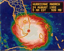
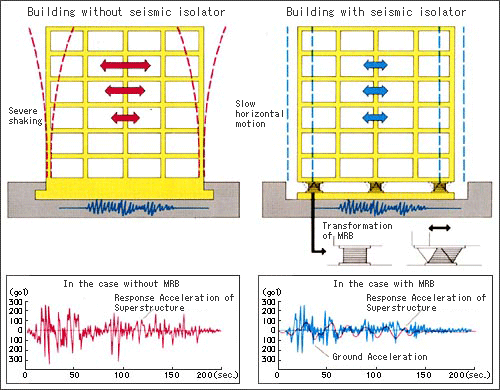
Earthquake: a violent shaking of the Earth’s crust

Emergency aid: help in the form of food, medical care and temporary housing provided 
immediately after a natural disaster

Epicentre: the point on the Earth’s surface that is directly above the focus of an earthquake

Hazard: an event which threatens the wellbeing of people and their property

Infrastructure: the transport networks and the water, sewage and communication systems that are vital to people and their settlements and businesses

Lahar: a flow of wet material down the side of a volcano’s ash cone which can become a serious hazard

Natural disaster: a natural event or hazard causing damage and destruction to property, as well as personal injuries and death

Natural event: something happening in the physical environment, such as a storm, volcanic eruption or earthquake

Plate movement: mainly the coming together and the moving apart of tectonic plates

Prediction: forecasting future events or changes

Pyroclastic flow: a devastating eruption of extremely hot gas, ash and rocks during a period of explosive volcanic activity; the downslope flow to this mixture is capable of reaching speeds up to 200kph.

Risk assessment: judging the degree of damage and destruction that an area might experience as a result of a natural event

Storm surge: a rapid rise in sea level in which water is piled up against the coastline to a level far exceeding the normal. It tend to happen when there is very low atmospheric pressure and where seawater is pushed into a narrow channel

Subduction: the pushing down of one tectonic plate under another at a collision plate margin. Pressure and heat convert the plate into magma

Tropical revolving storm: a weather system of very low-pressure formed over tropical seas and involving strong winds and heavy rainfall (also known as cyclone, hurricane or typhoon)

Tsunami: a tidal wave caused by the shock waves originating from a submarine earthquake or volcanic eruption

Volcanic activity: the eruption of molten rock, ash or gases from a volcano


Economic activity and energy

Economic sector: a major division of the economy based on the type of economic activity. The economies of all countries are made up of three sectors; most HICs have a fourth sector.

Energy: heat and motive power. The former provided by the sun and by burning coal, oil and timber, the latter provided by electricity, gas, steam and nuclear power

Energy consumption: the amount of energy used by individuals, groups of countries

Energy efficiency: making the most of energy sources in order to cut down on waste and reduce consumption

Energy gap: a gap created because the loss of energy caused by phasing out the use of fossil fuels is greater than the amount of energy that is being developed from new, low-carbon sources

Fossil fuel: carbon fuels such as coal, oil and natural gas that cannot be ‘remade/renewed’, because it will take tens of millions of years for them to form again

Global shift: the movement of manufacturing from HICs to cheaper production locations in LICs

High-tech industry: economic activities that rely on advanced scientific research and produce new, innovative and technologically advanced products, such as microchips, new medical drugs and new materials

Informal employment: types of work that are not officially recognized and are taken up by people working for themselves on the streets of LIC cities. e.g. shoe shining, selling stuff on the street

Non-renewable energy: energy produced from resources that cannot be replaced once they are used. Examples include the fossil fuels of coal, oil and natural gas

Primary sector: economic activities concerned with the working of natural resources-agriculture, fishing, mining and quarrying

Quaternary sector: economic activities that provide highly skilled services such as collecting and processing information, research and development

Secondary sector: economic activities concerned with making things, such as cars, buildings and electricity

Renewable energy: sources of energy which cannot be exhausted, such as the sun, wind and running water

Tertiary sector: activities that provide a wide range of services and enable goods to be traded

Transnational company (TNC): a large company operating in a number of countries and often involved in a variety of economic activities


Urban environments

Accessibility: the ease with which one location can be reached from another; the degree to which people are able to obtain goods and services, such as housing and healthcare

Brownfield site: land that has been previously used, abandoned and now awaits a new use

Congestion: acute overcrowding caused by high densities of traffic, business and people

Counterurbanisation: the movement of people and employment from major cities to smaller cities and towns as well as to rural areas

Environmental quality: the degree to which an area is free from air, water, noise and visual pollution

Ethnic group: a group of people united by a common characteristic such as race, language or religion

Greenfield site: land that has not been used for urban development

Land value: the market price of a piece of land; what people or businesses are prepared to pay for owning and occupying it

Megacity: a city or urban area with a population larger than 10 million

Poverty: where people are seriously lacking in terms of income, food, housing, basic services (clean water and sewage disposal) and access to education and healthcare. See also Social Deprivation.

Shanty town: an area of slum housing built of salvaged materials and located either on the city edge or within the city on hazardous ground previously avoided by urban development; I like to think of it as: a slum settlement (sometimes illegal or unauthorized) of impoverished people who live in improvised dwellings made from scrap materials: packing boxes, corrugated iron and plastic sheeting, often on undesirable locations such as steep slopes or on the city edge.

Social deprivation: when the well-being and quality of life of people falls below a minimum level

Social segregation: the clustering together of people with similar characteristics (class, ethnicity, wealth) into separate residential areas

Socio-economic group: a group of people sharing the same characteristics such as income level, type of employment and class

Squatter community: see Shanty town

Suburbanisation: the outward spread of the urban area, often at lower densities compared with the older parts of the city or town

Urban regeneration: the investment of capital in the reviving of old, urban areas by either improving what is there or clearing it away and rebuilding

Urban re-imaging: changing the image of an urban area and the way people view it

Urban managers: people who make important decisions affecting urban areas, such as planners, politicians and developers

Urbanisation: growth in the percentage of people living and working in urban areas


Fragile environments

Agro-forestry: the growing of trees for the benefit of agriculture: as wind breaks or as protection against soil erosion

Alternative energy: renewable sources of energy, such as solar and wind power, that offer an alternative to the use of fossil fuels

Chlorofluorocarbons (CFCs): chemicals once used in foams, refrigerators, aerosols and air-conditioning units. Their use is now banned because they were thought to be responsible for the destruction of the world’s ozone layer and for part of the greenhouse effect

Climate change: long-term changes in the global atmospheric conditions

Deforestation: the deliberate clearing of forested land, often causing serious environmental problems such as soil erosion

Desertification: the spread of desert conditions into what where semi-arid areas

Famine: a chronic shortage of food resulting in many people dying from starvation

Fossil fuel: carbon fuels such as coal, oil and natural gas that cannot be ‘remade’ because it will take tens of millions of years for them to form again (i.e they are finite)

Fragile: a term used to describe those natural environments that are sensitive to, and easily abused by human activities

Global warming: a process whereby global temperatures rise over time

Malnutrition: a condition resulting when a person is unable to eat what is needed to maintain good health

Overgrazing: when pasture or grazing is unable to support the number of animals relying on it for food. The result is the vegetation cover declines and soil erosion sets in.

Population pressure: when the number of people in an area begins to approach carrying capacity and places a strain on available resources

Refugee: a person whose reasons for migrating are due to fear of persecution or death

Soil erosion: the washing or blowing away of topsoil so that the fertility of the remaining soil is greatly reduced

Sustainable: a term used to describe actions that minimize negative impacts on the environment and promote human well-being

Well-being: a condition experienced by people and greatly influenced by the standard of living and quality of life 

Saturday 14 April 2012

The Three Gorges Dam, Yangtze River, China


In the IGCSE Geography Specification, you're meant to know a case study for a dam or reservoir project, and I learnt this, so...: 

Case Study of a Dam or Reservoir Project: The Three Gorges Dam, Yangtze River, China (multi-purpose scheme)
Yangtze River: Intro Facts
·         Source=Himalayas, flows into the East China Sea at Shanghai
·         3rd longest river in the world
·         Floods regularly, unpredictable, prone to severe flooding (every 10 years on average)
·         Last great flood-1998, an area the size of New Zealand was flooded
·         US$30 billion worth of damage
·         In the 20th century, over 300,000 people have been killed by the Yangtze floods

The Three Gorges Dam: A multi-purpose scheme
Main purpose: to prevent flooding downstream
Other uses:
·         Generates HEP (hydro-electric power)
·         Provides water to urban areas and to agriculture (irrigation)
·         Will improve river transport upstream

Cost-Benefit Analysis of the Three Gorges Dam

Benefits/Advantages/Positive Effects (in order of importance according to me)
1.       Control flooding downstream of the dam.
2.       Provides water to urban areas and for agriculture-irrigation. (The reservoir can store up to 5 trillion gallons of water.
3.       The HEP generated will provide 15% of China’s electricity demand.
a.       This will decrease China’s dependency on coal and therefore reduce greenhouse gas emission.
4.       Thousands of construction jobs were created during the building of the dam.
5.       China will be able to bring 10,000 ton ocean going vessels all the way inland, 2000km up to the city of Chongqing.
6.       The dam will become a tourist attraction and will attract a lot of people to the area. Many tertiary sector/service jobs will be created.
7.       The electricity generated will help the economic development of cities such as Chongqing, population=3 million.

Costs/Disadvantages/Negative Effects (in order of importance according to me)
1.       Several large towns upstream, such as Fuling (population=80,000) and Wanxian (population=140,000) will be flooded.
a.       Ancient temples, burial grounds and other historic sites will be lost beneath the reservoir too.
2.       Over 1.3 million people will have to be relocated.
3.       Much of the land used for resettlement is over 800m above sea level, where the climate is colder and the soil can barely support farming.
4.       The pressure created by the huge weight of the water in the reservoir behind the dam could trigger earthquakes. (But it is engineered to withstand an earthquake of 7.0 on the Richter scale.)
5.       The untreated human and industrial waste will not be washed away downstream, but will stay and pollute the river instead.
6.       Areas downstream will be deprived of fertile sediment.
7.       It will divert money from other developments. It is currently one of the most expensive projects in the world, costing more than $26 billion, over their budget.


Wednesday 11 April 2012

Fieldwork Opportunities: Hazardous Environments


Fieldwork Opportunities: Hazardous Environments


Measuring, collecting and recording weather data:
  • During the passage of a tropical storm, local weather stations will record an enormous increase in wind speed and rainfall.
  • Instrument area is used to measure local weather conditions in calmer, drier conditions-providing primary data.
  • Care and accuracy important when measuring weather-instrument itself has to be suitable as well as its use accurate.
  • Should have an easy to complete record sheet showing date, time and columns for each element of the weather you have instruments for. Eg maximum/minimum temperature and rainfall.
  • Records should be kept daily and for at least a week. Readings should be taken preferably at same time each day.

Rain Gauge:
  • It should be placed in open space so it can collect rain water straight from the sky.
  • Rain is collected in a measuring flask and the measurement can be read easily.
  • Once reading is noted, the water has to be tipped away daily.

Stevenson Screen:
  • Instruments used to measure temperature and humidity should be kept inside a Stevenson Screen.
  • It’s a wooden box used to shade from direct sunlight and radiation so that the instruments inside can measure air temperature.
  • It’s painted white to reflect sunlight and has vents to allow free flow of air. This makes the readings fair.
  • Maximum-minimum thermometer housed inside measures the highest and lowest temperature, often within a 24-hour period. –weather data should be standardised.
  • Readings have to be taken so that they can be compared with those taken at other places and at other times.
  • After noting temperature readings, the thermometer has to be reset by sliding the magnetic base over the mercury columns.

Cup Anemometer and wind valve:
  • Wind valve measures wind direction.
  • Cup anemometer is a weather instrument that measures wind speed/strength.
  • There are 3 to 4 cups mounted on a vertical pole. The cups catch the blowing wind and turn the pole.
  • Each time the anemometer makes a full rotation, the wind speed is measured by the number of revolutions per minute (RPM).
  • The number of revolutions is recorded over time and an average is determined.


Monday 9 April 2012

Why are the effects of natural hazards generally less harmful in HICs than in LICs?

Why are the effects of natural hazards generally less harmful in HICs than in LICs?


Preparation and prediction in HICs are usually better than in LICs thus the effects are less harmful. HICs are generally wealthier thus they can afford better prediction technology. For example, USA has top-notch satellite technology that feeds back to the National Hurricane Centre in Miami. This allows them to check the weather and satellite images to see if there is a hurricane forming; or to see if there is a possibility of a hurricane forming (for example if the ocean is at 27˚C). If one is forming, they can send out a warning to people at least 24-hours in advance. In LICs such as Bangladesh, they can’t afford such technology thus their citizens don’t have much time to prepare to evacuate-leading to more injuries and deaths. Japan is another example of a wealthy country that has good prediction equipment albeit for earthquakes.

Preparation in HICs is much better in several ways. Firstly, the warning systems are much better. For example in Florida, there are sirens, messages sent to mobile phones as well as news broadcasted via the radio, internet and television. This is much more effective than in LICs such as in Bangladesh where megaphones are used. A person cycles through the farms and city yelling out warnings through a megaphone. This is ineffective as there is a chance that many people won’t hear them. Also, many people in Bangladesh had no idea how bad the cyclone was going to be, and they did not know how to prepare. (Some did not believe the warnings.)
Moreover, their housing was of poor quality, so they did not need to strengthen it whereas in Florida people boarded up their windows. Furthermore, they had nowhere else to go for lack of hurricane shelters, and there was no transportation they could take. Thus they stayed at home. This resulted in more deaths as their houses may collapse on them, or they would be swept by the storm surge as they remained in low lying areas. (Due to lack of education in LICs, many people did not know the after effects of some natural disasters. For example, in Bangladesh, many people did not know about the storm surge that could flood areas and drown people. They also did not know about the eye of the storm, where it is calm. So they go outside to survey the damage only to be swept up by the hurricane when the eye passes. In other LICs prone to earthquakes, some people may not know about the aftershocks that could be quite high on the Richter scale too.)

Another reason why effects are less severe in HICs is they have stockpiles of food and water. These are kept in the shelters built in case of emergencies. (For example, in Florida, there are elevated shelters built along the coastline for people living near the coast to protect them from the storm surge.) In LICs, there isn’t as much food surplus so people can’t store cans of food; nor do they have the money to do so anyway. One effect of natural disasters in LICs is starvation and disease spreading. The water sources like reservoirs are contaminated, often with cholera, and people drinking it get sick and spread the disease. Agriculture is important in LICs, and with the crops destroyed by the disaster the people have no food to eat. Many people die of starvation. On the contrary, in HICs, people can still survive with stockpiles of canned food and water prepared beforehand.


There are less deaths in HICs because the people are well prepared. They have constant drills and practices so that they know what to do when an emergency occurs. For example in Japan, all the schools have frequent earthquake drills where people practice evacuating or hiding beside tables. In Florida, there are even evacuation routes and road signs directing people to safe areas. In LICs, the transportation system is less organised and there aren’t any safe places for people to evacuate to. Also, the infrastructure is weak leading to bridges and highways collapsing. This could injure a lot of people. Traffic lights also cease to function, hence leading to traffic jams-so even if people want to evacuate, they would be stuck. In HICs, there are buildings designed to be resistant against natural disasters. For example, the Taipei 101 in Taiwan is designed to be earthquake-resistant. It has a tuned mass damper that swings in the opposite direction the building does in an earthquake to prevent it from collapsing. In Japan, buildings have to comply with regulations to make it earthquake resistant so that less people are harmed by falling debris from collapsing buildings.

The responses in HICs really help reduce the effect of natural hazards. Short-term responses such as rescue teams (firefighters, search and rescue teams, ambulances etc) have had regular training thus they know what to do. They won’t panic, they have the transport to get to places in need of help, and they also have sufficient equipment. This is good because they can save a lot more people if they are well prepared. In LICs, training, transport and equipment need a lot of money and so they cannot afford it. The response is sluggish and poor as people are momentarily dazed and do not know what to do. For example, in Bangladesh, the rescue teams did not have enough medical equipment and they did not have enough simple things like plasters. They did not have torches or blankets to provide people with comfort and many people died without sufficient aid and medical treatment. In HICs, there were backup electricity and water sources so people were able to live quite comfortably. They also set about to repair any damaged telephone lines so that people could contact family. This reduced any trauma people suffered as they felt more secure and they knew their family was informed.

The long term responses in HICs such as rebuilding any collapsed infrastructure and housing was much better as they could afford to do so. HICs such as Japan and Florida managed to rebuild most of the buildings, transport infrastructure and housing units within a decade of the disaster. They also improved building designs to make it more resistant. In LICs such as Philippines, there are still people displaced from the Mount Pinatubo eruption as the country does not have the money to rebuild all the houses. They also don’t have money to build it well. Many people still have to live in temporary housing with poor facilities. The resettling of people in LICs is not effective and it is often very slow. LICs such as Bangladesh and Philippines are interdependent, they have to rely on other countries to give them financial aid and more.


Thursday 5 April 2012

Kobe Earthquake, 1995


Based on my own research, some data could be different to what you find.. 

Case Study of the Management of a Tectonic Event in an HIC: Kobe Earthquake, 1995


Intro facts: Cause of the earthquake:
  • The earthquake was caused by the Philippines Plate being subducted under the Eurasian Plate.
  • The focus was very shallow; it was only about 15km.
  • The epicentre was very close to Kobe, around 20km away.

Intro facts: Short term impacts of the earthquake
  • Nearly 200,000 buildings were destroyed.
  • A 1km stretch of the elevated Hanshin Expressway collapsed.
  • 120 of the 150 quays in the port of Kobe were destroyed.
  • Electricity, gas and water supplies were disrupted.
  • Fires caused by broken pipes and ruptured electricity lines, swept the city.
  • An estimated 230,000 people were made homeless.
  • The number of deaths was put officially at 5500.
  • At lest 40,000 people suffered serious injury.

How Was The Earthquake Disaster Managed?

Before the earthquake: Prediction
  • The Japanese government established the Imperial Earthquake Investigation Committee in 1892 in response to the Nobi earthquake (1891) which caused significant damage in Japan. However, they failed to predict the Great Hanshin Earthquake.
  • Even though Japan has one of the most advance Earthquake prediction systems, they failed to predict it. Kobe had not had a major earthquake for more than 400 years so there was less prediction equipment there than in other areas of Japan.
  • Although people on duty could see that there were many tremors (prior to the earthquake), they did not raise the alarm. It could be that they were getting complacent because they had not received a huge earthquake for a long time.
Before the earthquake: Preparation 
-        Illusion of preparedness made people complacent-caught unaware.
-        There were still many old, traditional houses in Kobe. They had heavy tiles on the roofs to withstand typhoons; but they injured many people when the wood supporting the roof collapsed.
-        Most new buildings built had been designed to be earthquake proof; but because of liquefaction, they still toppled over. The houses were not retrofitted, resulting in many elderly people injured.  Transport infrastructure not retrofitted either.
-        They didn’t have sufficient emergency supplies. Especially water-couldn’t fight fire efficiently.
+        Schools and factories had regular earthquake drills.
After the earthquake: Response In The Short Term
·         They had to get clean, fresh water from other parts of the country.
·         The Japanese government evacuated people into temporary shelters because they still faced the dangers of fires and unstable buildings. The government was criticized for being so slow in mobilizing the army-sluggish response.
·         Bulldozers were brought in to clear fallen buildings.
·         The local fire department put out the fires.
·         Civilians helped to rescue others who were trapped.
·         Medical aid centres were set up.
After the earthquake: Response In The Medium & Long Term
  • By January 1999, 134,000 housing units had been constructed. All homes and buildings had to be built to strict regulations and they were made more earthquake resistant. (Flexible frames, steel support.)
  • Water, electricity, gas and telephone services were fully working by July 1995.
  • Within a year, 80% of the port was working but the Hanshin Expressway was still closed.
  • The railways were back in service by August 1995.
  • More instruments were installed in the area to monitor seismic activity.
  • Major transport routes were reinforced so they do not get destroyed or damaged in the event of another major earthquake.
  • Earthquake resistant shelters were constructed in local parks.
  • The city plan was more spaced out, buildings were further apart so that if one collapsed, it would not create a domino effect. Buildings were not allowed to be built on unstable land.
  • Developed more open space in the city so that people had a large area to evacuate to.
  • Japan refused international aid for a while then finally let them in.


Wednesday 4 April 2012

Case Study of Impacts of a Tropical Storm in an HIC

Note: this is based on my own research and 'fact's are different from site to site..so it could be different from what you find! 
http://www.nhc.noaa.gov/1992andrew.html

What Are The Impacts Of A Tropical Storm In An HIC?
Case Study: Hurricane Andrew - Florida, USA (August 1992)

Fact File
Date: 24th August 1992
Category: 4
Ocean it formed in: Eastern Atlantic
Direction it came from: Travelled in West & Northwest direction- headed                               towards the Lesser Antilles
Name of a city affected: Florida
Wind speed: 240km/h (150 mph)
Storm surge: 5 metres

Effects
Deaths: 30
Injuries: hundreds seriously injured
Cost of damage: Total cost estimated over ₤50 billion, Insurance claims in excess of ₤12 billion
No. of homes destroyed: 25,000 homes destroyed, 100,000 badly damaged
Number of homeless: 175,000 in South Florida alone
Damage to transport infrastructure: 52 roads blocked, 9,500 traffic signals damaged
Electricity supplies: 5311 metres of power cables destroyed, 1.3 million homes and businesses left without power
Most damage caused by winds or storm surge: Winds
Environmental damage: Hundreds of hectares of forest flattened, 25,000 gallons of oil spilled into Biscayne Bay, 33% of coral reefs damaged at Biscayne National Park, Killed 7 million fish due to depleted oxygen in waterways, 8% of all Florida agriculture destroyed
Other effects: 82,000 businesses destroyed/closed down, 120,300 job losses


The Case Study of Impacts of a Tropical Storm in a LIC can be purchased by buying my full set of IGCSE Geo Notes. :) 
Contact: michelle.lim205@gmail.com

Monday 2 April 2012

Earthquake-Resistant Building Design

This is based on a piece of HW and is my own research..there are lots more you can find out for yourself though! :)


Earthquake Resistant Building Design

Taipei 101

The Taipei 101 is located in Taipei, Taiwan. It started construction in 1999 and was completed in 2004. It is 101 stories above ground and 5 stories below. It is 509.2 meters tall.

1.      The design of this building achieves strength and flexibility through the use of high performance steel construction. Taipei 101 is supported by 36 columns, as well as 8 ‘mega columns’ made with 10,000 psi (pounds per square inch-a unit of pressure) concrete.

2.      Every 8 floors, outrigger trusses connect columns in the building’s core to those on the exterior. This makes it one of the most stable buildings in the world.

3.      The foundation of the Taipei 101 is very strong. It has 380 piles 80 meters deep in the ground, it extends as far as 30 meters into the bedrock. Each pile is 1.5 meters in diameter and can withstand a load of 1,000-1,320 tonnes.

4.      One interesting feature of the Taipei 101 is its steel pendulum. It serves as a tuned mass damper that weighs 660 tonnes. It cost US$ 4 million. It is suspended from the 92nd to the 88th floor and can be viewed. It is computer controlled, if the building sways to one side due to strong winds or seismic waves, it goes in the opposite direction. It offsets the movement of the building. This keeps the building balanced and prevents it from being top-heavy and collapsing.

5.      The blue-green glass are double paned and glazed. They offer heat and ultraviolet protection and can block external heat by up to 50%. It can sustain impacts of 7 tonnes.

Tuned Mass Damper


Torre Mayor

The Torre mayor is in Mexico City. It started construction in 1999 and was finished in 2003. It has 57 stories and is 225 meters tall.
It uses large Fluid Viscous Dampers as a primary means of seismic energy dissipation. There are a total of 98 dampers, 24 of which are large; each rated at 570 tonnes output force. They are located in the long walls of the building. The short walls have 74 smaller dampers, each rated at 280 tonnes output force. The dampers are installed in mega brace elements, up to 20 meters in length. A single damper can span up to six floors.
http://science.howstuffworks.com/engineering/structural/smart-structure.htm

Earthquake Isolated Base Technology

This technique uses a coil or any other flexible support placed in between the structure's foundation. There is a movement interaction with the seismic waves, thus if the earthquake moves the foundation in one direction, the support will move the opposite direction and this confers immobility to the building. Some modern building are incorporated with cross-supports in between frame support, these also hold building together during tremor.


Was this useful?